Iceland > Drinking Water
The summary is we are definitively going to have to carry some water. Trying to work out how much water we need to carry depends on the route we take. But of course, we will select the route based on access to drinking water. The largest distance between reliable water sources is around 58 kms, which would be 2 quite long days. There are some less reliable water sources that could reduce this down to slightly more comfortable distances.
Below is an analysis of drinking water availability, as best as we can tell. Once we are actually in Iceland, we will be able to get much better information. But a bit of pre-analysis seems prudent.
There will be some days when we know that there will be no water during the day or in the evening once we arrive. On these days we should probably carry between 4 and 5 liters of water. So, adding water bags to the kit list for this trip. Below we look at the route to see what part of the route might have challenges to get drinking water.
1 – Hraunhafnartangi Lighthouse to Ásbyrgi
The section from Hraunhafnartangi Lighthouse to Ásbyrgi is about 80 kms long and will take about 4 days to complete. It seems there is sufficient drinking water along this part of the route. The image below shows the water coverage on August 11th, 2024. The dark blue colour indicates the presence of water and the lighter blue line is a possible route. The lakes alongside the route are indicated on maps, so presumably they do not dry up each year. But if we can’t find suitable drinking water, then we will need to divert to Kópasker.
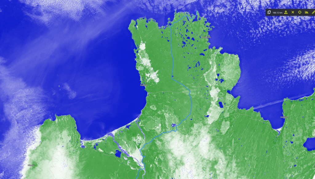
2 – Ásbyrgi to Reykjahlid
The section from Ásbyrgi to Reykjahlid is about 70 kms long and will take about 3 to 4 days to complete. The first 30 kms are along the Jökulsá á Fjöllum river, and the map shows springs feeding various little creeks. There is also access to the river at Jökulsárgljúfur (100 kms; 65.88626º, -16.44765º). The tourist area of Dettifoss will clearly have water (111 kms; 65.81534º, -16.38661º). Appears the next reliable water source is at Lake Eilífsvötn (125 kms; 65.76605º, -16.57861º) which is about 25 kms or 1 day from Reykjahlíð, where we will also have a food drop. Along the way is Krafla, a crater filled with water, but this water probably not safe to drink. Although others camped near the crater, and presumably there was water there, and little creeks are shown on the map. Would be nice if we can do this section in 4 days instead of 3.
3 – Reykjahlid to Nýidalur Hut
The central highlands and the Ódáðahraun Desert are likely to be the most challenging for drinking water.
3.1 – Base Route:
Leaving Reykjahlid and staying on the base route along Mývatn Lake provides drinking water for the first 15 kms. Beyond this point we likely have to carry water in some places. Around 200 kms (65.28163º, -17.04019º), we can make a short diversion to Botni Hut, where water is reported to exists. A further 20 kms along at Dyngjufell Hut there is also water. After this point we will need to carry water, as Kistufell Hut is 52 kms away. This would be a tough 2 day water carry. After the carry, water is available at Gæsavatnaskáli Hut a further 20 kms and finally at Nýidalur Hut, another 37 kms. Depending on the exact places we are camping, we might need to carry the last part to Nýidalur Hut. Although between Gæsavatnaskáli Hut and Nýidalur Hut there might also be water and places to camp. There is also a huge glacier after Kistufell Hut, so if the huts does not have water, we could melt ice. The summary is that the base route for this section is likely viable, even if it means carrying some water. And others have done it.
3.2 – Alternative Route
3.2.1 – Dyngjufell Hut to Dreki Hut: A distance of 24 kms between huts. So camping at huts or a water carry if camping between huts.
3.2.2 – Heilagsdalur Hut to Dreki Hut: A distance of 58 kms, but potentially water via rainwater tanks at Bræðrafell Hut being 40 kms from Heilagsdalur Hut. Certainly a water carry and potentially a tough one.
3.2.3 – Dreki Hut to Kistufell Hut: Quite a few trip reports indicate that this a very dry section. Fortunately the rangers at Dreki Hut will be able to tell us what the situation is as we head South. The distance between Dreki to Kistufell huts is 56 kms, so a tough 2 day water carry would be sufficient. Svartárlindir Spring is at (64.95720º, -16.56719º) which is on a Lake with another nearby Lake. Ideally we could camp at the Svartárlindir Spring bringing the water carry down to 46 kms and an easier 2 day water carry.
3.2.4 – Kistufell Hut to Nýidalur Hut: Gæsavatnaskáli Hut is 20 kms beyond Kistufell Hut, and Nýidalur Hut a further 21 kms beyond that. So, water is looking good after Kistufell Hut.
The table below provides a summary of water at the various huts in this section.
| Water Locations | Latitude, Longitude | Source |
|---|---|---|
| Heilagsdalur Hut | 65.45533, -16.79140º | Rainwater Tanks |
| Botni Hut | 65.26955º, -17.06803º | Suðurá River |
| Dyngjufell Hut | 65.12496º, -16.92083º | Nearby Stream |
| Bræðrafell Hut | 65.18804º, -16.53807º | Rainwater Tanks |
| Dreki Hut | 65.04178º, -16.59442º | Nearby River |
| Kistufell Hut | 64.81145º, -17.23315º | Nearby River |
| Gæsavatnaskáli Hut | 64.77789º, -17.51339º | Nearby River |
| Nýidalur Hut | 64.73592º, -18.07461º | Nearby River |
4 – Nýidalur Hut to Landmannalaugar
4.1 – Base Route: This section is 126 kms long. The rangers at Nýidalur Hut will be able to tell what the situation is further South, but the multiple river crossings suggest this is not going to be a problem. Also, a previous hiker recorded all the water sources South of Nýidalur Hut and we have this information. Although hard to tell how accurate it is, as it might change from year to year.
4.2 – Alternative Route. A little longer at 147 kms. Again, we will take advice form the rangers, but again, there seem to be plenty of water along this route. After leaving Nýidalur Hut it is around 20 kms to Hágöngulón Lake. from here it is 32 kms to Jökulheimar Hut with a single water crossing about half way along. But Jökulheimar hut has a nearby water source, so potentially either a long day or a water carry. After Jökulheimar Hut there is lots of water.
5 – Landmannalaugar to Dyrhólaey
This is a very well known route, so no concerns whatsoever for this section.