Iceland > Alternative Routes
Our goal is to walk from Iceland’s northernmost lighthouse to it’s southernmost lighthouse. There is no “official” trail for this journey, so we have the flexibility to chart our own route. We have spent time researching previous North to South crossing of Iceland. The experiences and GPS tracks that others have shared on the Internet have been hugely valuable to us in creating our own base route.
However, most previous travelers have been adventure athletes or solo hikers who followed a very direct path from north to south, often minimizing time spent on the trail over prioritizing exploration. Our approach is more relaxed and adventurous. We want to fully embrace the journey; exploring the remote highlands, visiting points of interest, and adapting our route to maximize both safety and enjoyment. While we’ll start with the same base route as those before us, we plan to make adjustments along the way based on circumstances and preferences.
Alternative Routes and Side Trips
After carefully reviewing maps, we’ve identified several potential changes to the base route, which we refer to as alternative routes and side trips. Here’s how we define these terms:
- Alternative Routes: These diverge from our base route at certain points and reconnect later at a different point, often adding extra kilometers in exchange for scenic rewards or opportunities to visit tourist attractions.
- Side Trips: These are short detours, usually to tourist attractions or points of interest, that return to the same point on the base route.
To make things easier to follow, each alternative route or side trip is assigned a unique Greek letter and categorized with a colour based on its “trustworthiness”, being a measure of how much we trust that the route is in fact viable and we can can complete it.
- Base Route
- Magenta: The base route is marked in magenta and is highly trustworthy, following sealed roads, well documented 4×4 gravel roads, marked walking tracks, and bridges to cross large fast moving rivers.
- Alternative Routes and Side Trips
- Black: Routes marked in black are based on sealed roads or reliable walking tracks, which are certain to exist and offer the highest level of trust.
- Blue: Routes marked in blue are based on known 4×4 roads or walking tracks, these roads and trails are marked on digital maps and visible on satellite imagery. These routes do cross unbridged rivers, so the routes may not be viable under certain river conditions.
- Orange: Routes marked in orange are across open terrain and not following any routes indicated on maps. While these routes are not established tracks, we believe they are still possible to navigate. We will however be making our own path.
Decision-Making in the Field
Given that Iceland’s conditions can change rapidly, we won’t make route decisions before the trip. Rather, we’ll be making key decisions in the field based on real-time assessments of terrain, weather forecasts, access to drinking water, where we have managed to cache our food packages and the preferences of the group. Factors such as the severity of winter, the timing of seasonal snow melt, and the strength of glacier-fed rivers will all influence which routes are viable at any given moment.
To ensure flexibility, we’re analyzing each alternative route and side trip in detail before the trip. This preparation will give us the information we need to make informed decisions during our trek. By gathering this knowledge in advance, we’ll be able to adapt to changing conditions and choose the safest and most rewarding route as we go. Preparation is also key, as we will not have reliable access to the Internet during our trek.
Below is a list of the alternative routes and side trips we’re considering. Some of these require a more detailed information and analysis, which is provided separately to avoid overwhelming this page with too much detail.
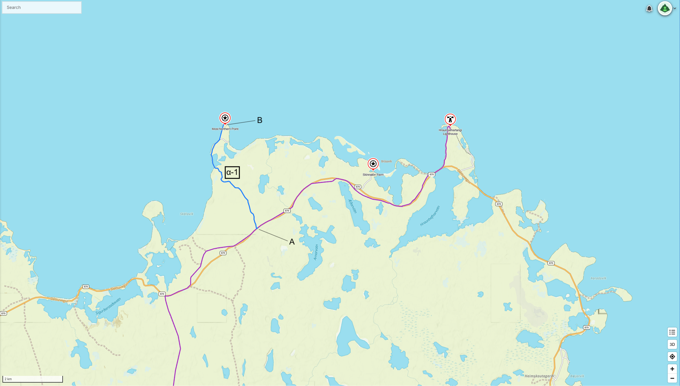
α – Northern Most Mainland Point Side Trip
Rifstangi is the northernmost point on mainland Iceland, located 400 meters further north than the Hraunhafnartangi Lighthouse which is our starting point. It is a 4.5 km (one-way) along a track to visit the far north. Both Rifstangi and Hraunhafnartangi are just 3 kms south of the Arctic Circle. If we want to claim to hve been to the most northern point of mainland Iceland, then we need to take tis side trip.
| Route | Routing | Distance (kms) | ↑/↓ (m) |
|---|---|---|---|
| α-1 | A → B → A | 8.9 | 0 / 0 |
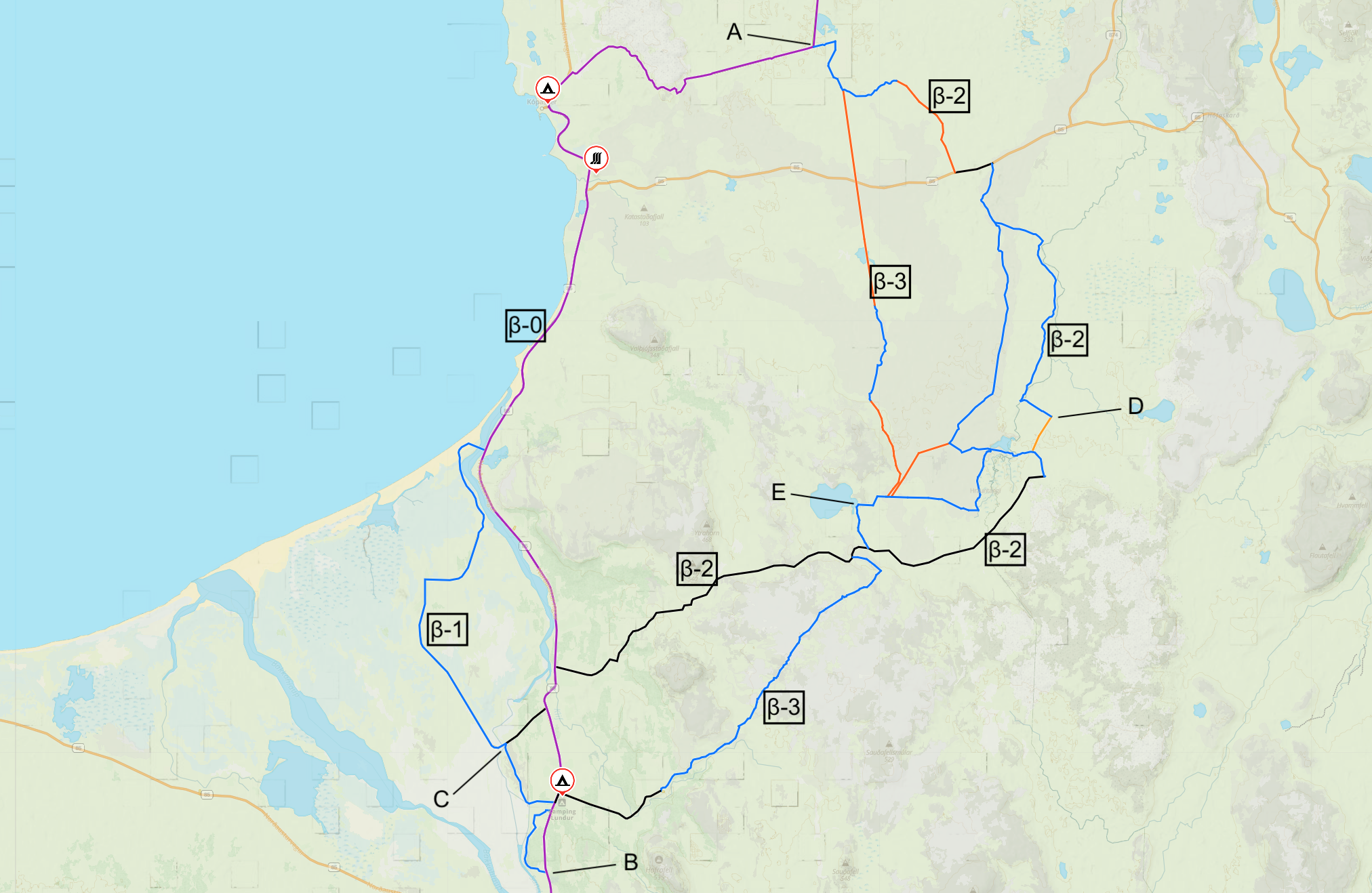
β – Avoid Norðausturvegur Costal Road
Following the base route, there is a 38 kms long sealed road from Kópasker to Ásbyrgi. That would be almost two days of walking along a busy sealed road. There are two alternatives routes available to bypass some or all of this sealed road.
- Some: The first alternative, β-1, is to walk the first 15kms from Kópasker along the sealed road and then take smaller roads to the west that run near the sealed road. This route crosses the Brunná river with a footbridge and follows the western bank until crossing the Sandá river and then rejoins the base route. This alternative route is 6 kms longer than the base route but removes 16 kms of sealed road. β-1 assumes that the pedestrian bridge at the water treatment plant is open so we can cross the river.
- All: The second two alternatives, β-2 and β-3, is to skip both Kópasker and the main road completely, and instead stay inland navigating the tundra and eventually connecting with either the Öxarfjarðarheiði road or a smaller but more direct track. Both of these alternatives leave only a few kilometers of sealed road walking near Ásbyrgi. However it does add up to 13 kms to the total distance depending on the exact route taken in the tundra.
- There are some disadvantages of β-2 and β-3:
- As we would skip Kópasker we would also skip the cafe and any chance for coffee and re-supply.
- There is a waterfall we would miss.
- If we take β-2, we still have to walk along the Öxarfjarðarheiði Road, which is a gravel road and is around 23 kms long, depending on the exact route we take. So still quite a bit of road walking, just not on a more busy sealed road.
- It might be slow going through the tundra as there are places with no established path.
- There are some considerations if we take one of the inland routes:
- We could visit either Lake Gæsavatn or Lake Arnarstaðavatn.
- Based on satellite imagery, it appears that some of the trails of the inland route are not well maintained, so it will be more adventurous! Probably require a little of route finding. Specifically, there is no obvious direct route to Lake Gæsavatn, so several possible routes are shown on the map below. Some are along marked tracks.
- Drinking water sources seem to be available along this route. Looks like Lake Arnarstaðavatn feds the Ormarsá river.
- Will not need to camp alongside a busy road or at an established campground.
- Finally, a previous hiker passed Lake Arnarstaðavatn, so that is encouraging. Although can’t find any evidence that someone has taken β-3.
- There are some disadvantages of β-2 and β-3:
- β-2 : After leaving Lake Beltisvatn, the first 5.2 kms follow known tracks followed by 4.2 kms of no track. The route has been established by someone that publish their route. Then a short road section before 12.4 kms of known track followed by 1.5 kms of no track. Another 1 km along known track and then 26 kms along the Öxarfjarðarheiði Road. The last section is shared with β-1. so, a total of 5.7 kms of no track.
- β-3 : After leaving Lake Beltisvatn, the first 2.7 kms follow known tracks followed by 8 kms of no track. Then 4 kms of known track and 3.9 kms of no track following the contours of a sizable hill. The next 1.3 kms to Lake Gæsavatn are along a known track. After the lake it is 15.5 kms along known track and 4.75 kms along a gravel road to return to β-0. Then follow β-1. So, a total of 12 kms of no track and an overall distance virtually the same as the base route.
There are other combinations and routes available, some of which are shown on the map below. The route between β-2 and β-3 actually follows known track all the way, and has the option of both Lake Arnarstaðavatn and Lake Gæsavatn, so this is quite an interesting option as well. The intent here is just to surface that options exist.
| Route | Routing | Distance (kms) | ↑/↓ (m) |
|---|---|---|---|
| β-0 | A → B | 43.8 | 677 / 764 |
| β-1 | A → C → B | 49.5 | 641 / 690 |
| β-2 | A → D → C → B | 59.3 | 834 / 917 |
| β-3 | A → E → B | 44.6 | 355 / 426 |
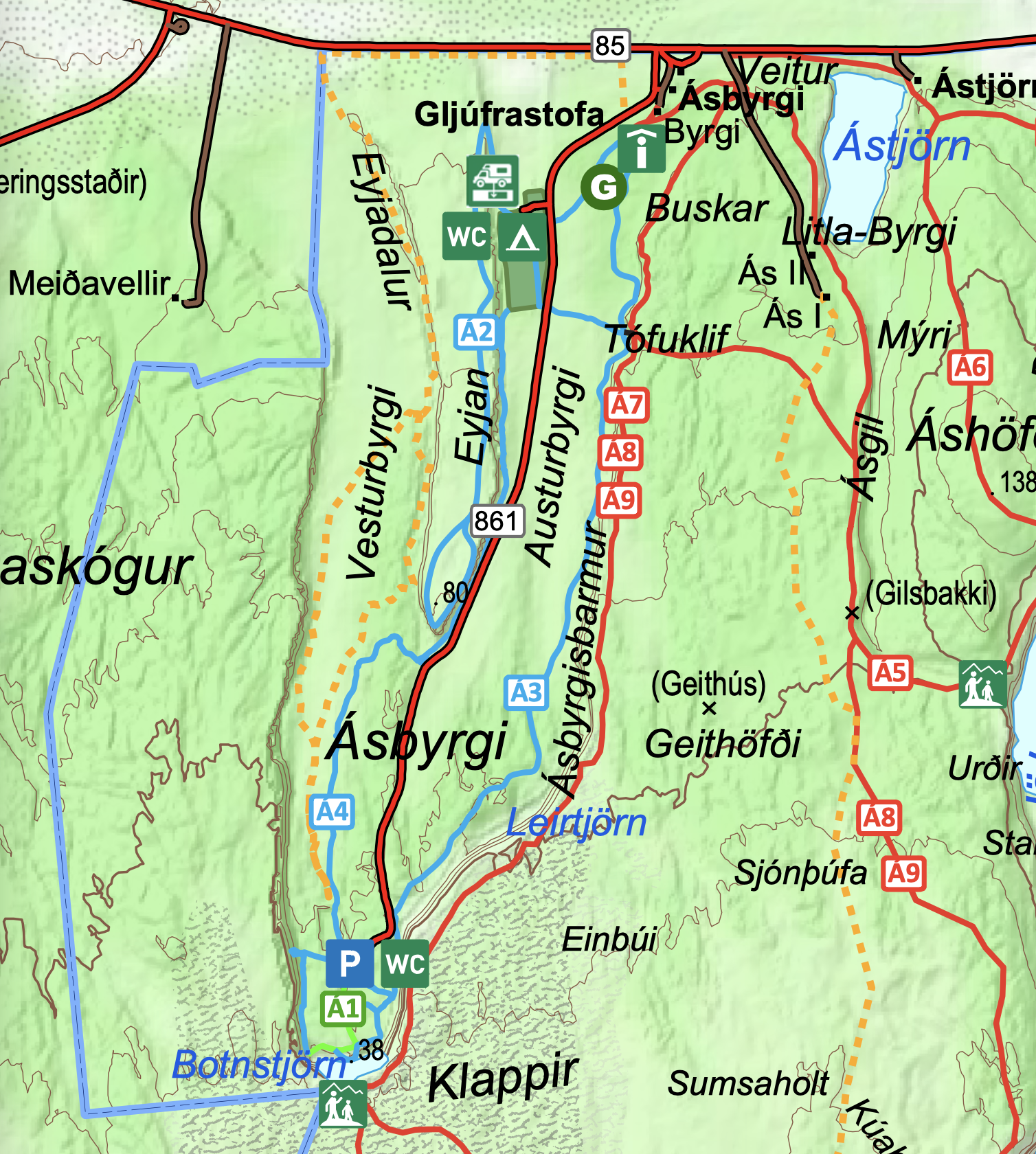
γ – Ásbyrgi Canyon Side Trip
Ásbyrgi is a glacial canyon and forest. The horseshoe-shaped depression is part of the Vatnajökull National Park and measures approximately 3.5 km in length and over 1 km wide. This could make an interesting side trip, all dependent on where we camp. We may also have a food drop to collect at Ásbyrgi.
The following trails are a taste of what is on offer at Ásbyrgi Canyon, should we choose to spend a half or full day there. The information and map below are from the Ásbyrgi area brochure:
- Á1 Botnstjörn pond (in and out) 1 km/0.5 hr. Ásbyrgi parking – Botnstjörn pond – viewpoint – return. Points of interest: Vegetation, birds and view of pond.
- Á2 Eyjan hill in Ásbyrgi (in and out) 4.5 km/1.5-2 hrs. Campground – Eyjan – campground. Points of interest: Beautiful view of Ásbyrgi. Enjoyable evening stroll.
- Á3 Skógarstígur – through the woods Dalfjall (one-way) 4 km/1.5 hrs. Visitor Centre – Ásbyrgi parking. Points of interest: Forest history. Vegetation and birds.
- Á4 Below Eyjan hill (one-way) 3.5 km/1 hr. Campground – Ásbyrgi parking. Points of interest: Honeycomb weathering, woods and other vegetation.
δ – Leaving Ásbyrgi
The base route (δ-0) takes a direct route south. There are various alternative routes we could take when leaving Ásbyrgi. This can all be decided when we are there. Just highlighting that we have options when leaving Ásbyrgi.
- For example, from Klappir we could take Á8 towards Jökulsá á Fjöllum river, and then Á9 to allow more time walking along the river. This alternative adds 3 kms to the total route.
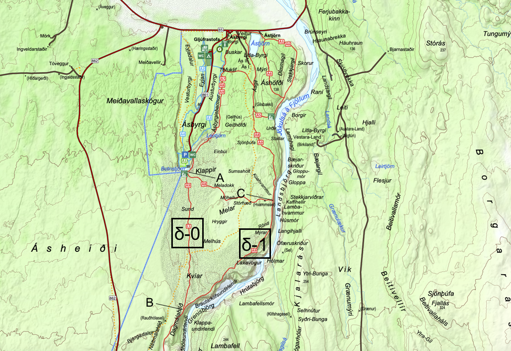
| Route | Routing | Distance (kms) | ↑/↓ (m) |
|---|---|---|---|
| δ-0 | A → B | 3.7 | 87 / 0 |
| δ-1 | A → C → B | 7.1 | 101 / 10 |
ε – Exploring Karfla Geothermal Areas
There are quite a few things to see and do around Mývatn and the Krafla geothermal area, including:
- Endless Shower (D). Hot water spring made into a shower beside the road.
- Námafjall (E), also known as Hverir. Able to see many smoking fumaroles and boiling mud pots, surrounded by sulphur crystals of many different colours. This sulphur gives the area an overwhelming smell of egg.
- Mývatn Nature Baths (F). Geothermally heated waters pools and steam baths. It is recommended you book tickets in advance in the summer.
- Grjótagjá (G). A small lava cave with a hot spring inside. Featured in Game of Thrones.
We probably want to explore most of these attractions. The base route goes directly to Reykjahlíð. From there we would back track to explore the attractions. The alternative route passes by the attractions along the way to Reykjahlíð. If we want to visit the attractions, both options, ε-0 and ε-1, are about the same distance and take the same time, just need to decide what order we do things in. If we do not want to visit the attractions, then ε-0 is shorter and faster.
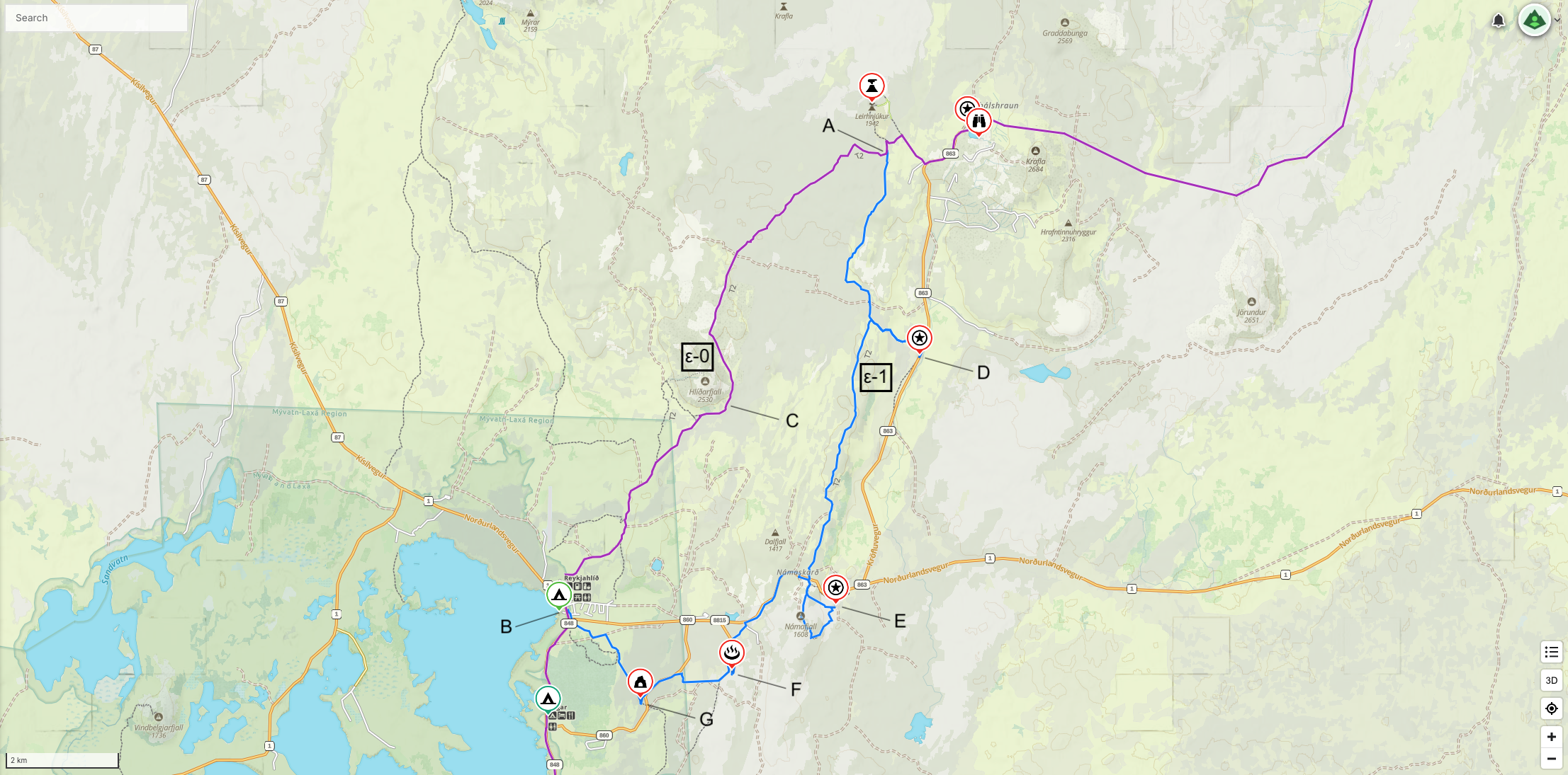
| Route | Routing | Distance (kms) | ↑/↓ (m) |
|---|---|---|---|
| ε-0 | A → C → B | 12.0 | 132 / 399 |
| ε-1 | A → F → B | 21.0 | 212 / 483 |
ζ – Volcanoes of the Mývatn Region
The base route (ζ-0) passes along the east side of Lake Mývatn and continues South. There are two an alternatives to the east which allows better access to the Krafla volcanic attractions, including:
- Hverfjall Volcano (D). An exploded volcano with a rim walking trail.
- Dimmuborgir (E). A large area of unusually shaped lava fields. Could be a cafe here as well. Dimmuborgir is also accessible from the base route.
- Lúdentarborgir (F). Viewpoint over craters.
- Seljahjallagil (G). A natural monument renowned for its striking basalt columns.
There are some attractions along the shores of Lake Mývatn, like Klasar, which are lava rock formations. The secondary advantage of the various alternative routes is avoiding 11 kms of sealed road between points A and C.
- ζ-1: Allows visits to all of the volcanic attractions and then heads back to the base route.
- ζ-2: Very similar to ζ-1 except continue South and rejoin the base route later. ζ-2 has as the advantage of avoiding some of the 4×4 road of the base route.
- θ-1: Complicated. If we have desires to take θ – Adding Lake Askja (see below), then we have the option to travel to Heilagsdalur Hut (H), obtain water and then head through the Ódáðahraun Desert towards Lake Askja.
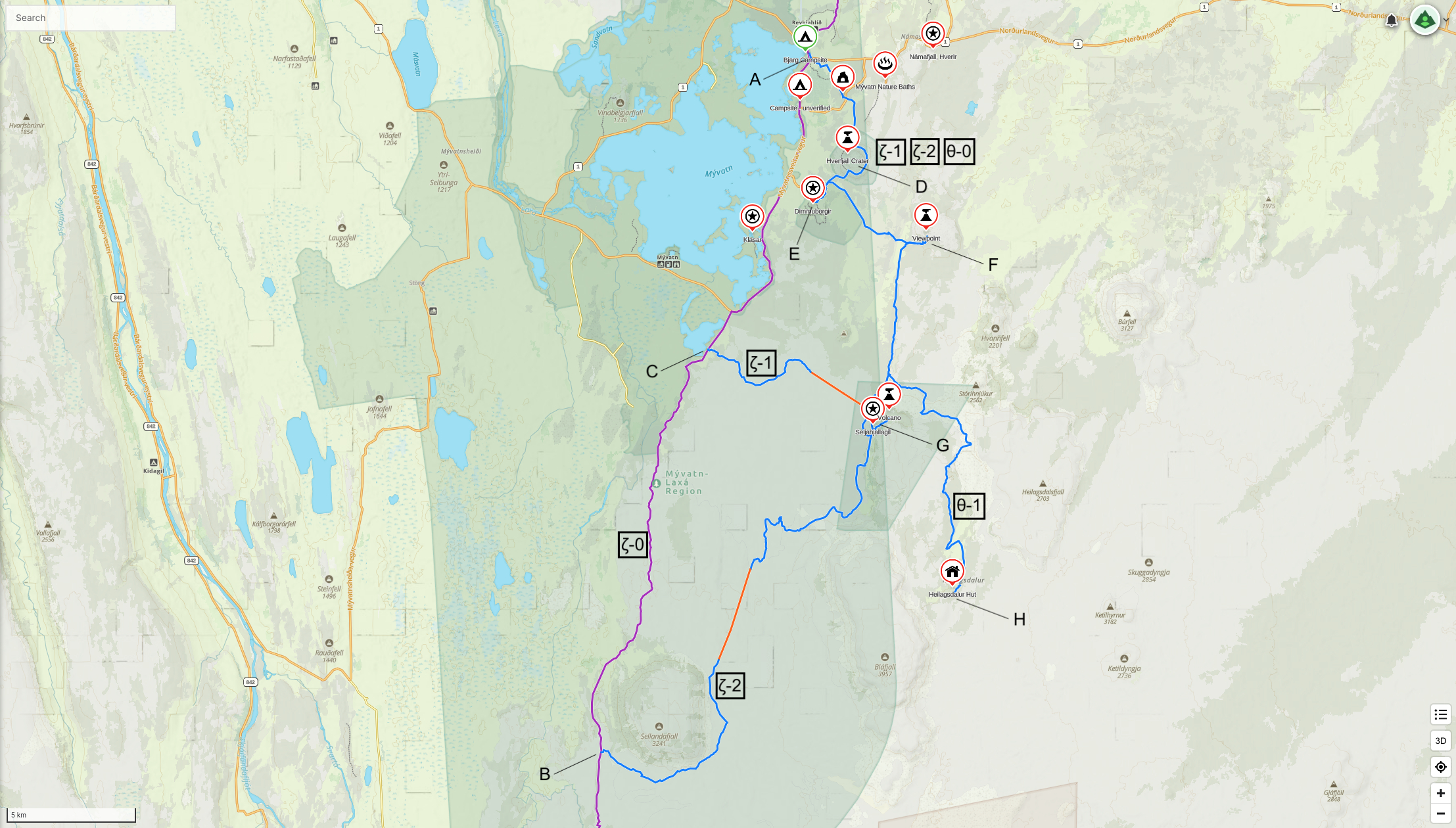
| Route | Routing | Distance (kms) | ↑/↓ (m) |
|---|---|---|---|
| ζ-0 | A → B | 34.5 | 789 / 654 |
| ζ-1 | A → G → C → B | 51.7 | 848 / 764 |
| ζ-2 | A → G → B | 50.5 | 1,217 / 1,108 |
ζ-3 is on the Gaia map, and it connect ζ-2 to θ-1 if there is too much snow in the North.
η – Botni Hut
If access to drinking water is a problem or the forecast predicts bad weather coming, the alternative via Botni Hut maybe a good idea. Overall a little longer, but also avoids the 4×4 gravel road. The longer alternative route also provides more camping opportunities. As shown on the map below, it is also possible to go to Botni Hut (at D) from the base route (at C), and it is only a few kms away. Both Botni Hut and the first half of the alternative route appear to have drinking water.
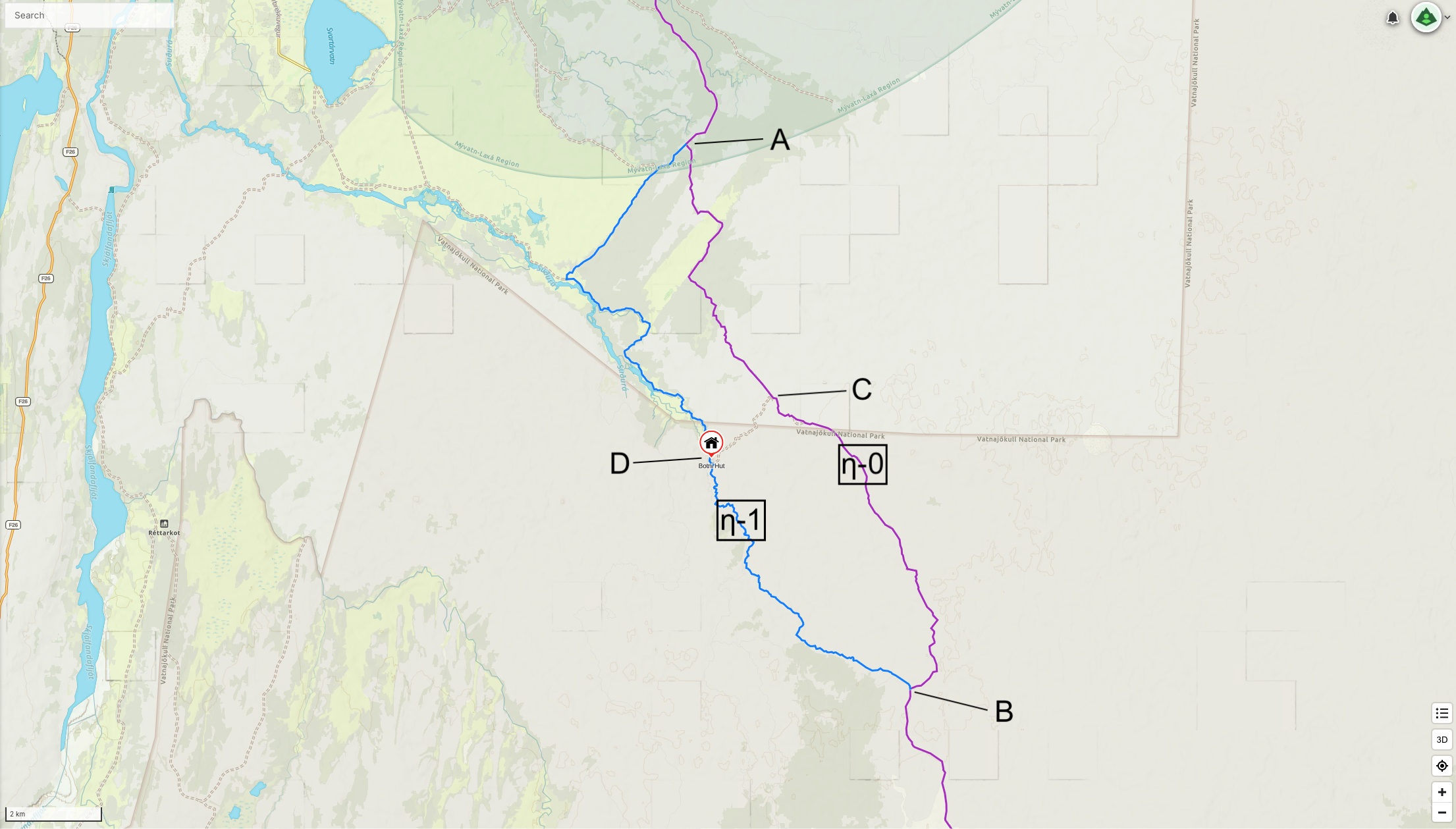
| Route | Routing | Distance (kms) | ↑/↓ (m) |
|---|---|---|---|
| η-0 | A → C → B | 15.4 | 239 / 160 |
| η-1 | A → D → B | 19.1 | 236 / 171 |
| – | C → D | 2.6 | 0 / 16 |
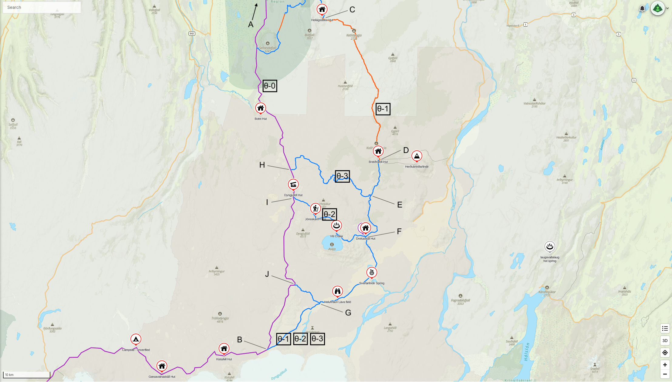
θ – Adding Lake Askja
It would be really nice to see Lake Askja. Unfortunately it seems to be a bit tricky to get there. So, some of the following route options are more on the creative side. Regardless, the three/four potential alternative routes considered are:
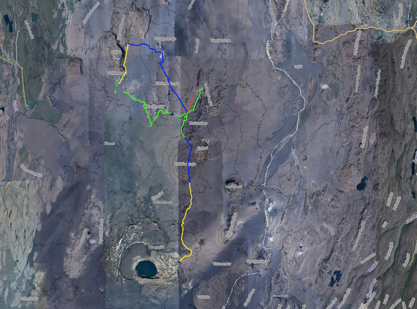
- θ-1: Continuation of ζ – Volcanoes of the Mývatn Region until Heilagsdalur Hut and then head East towards Skjaldbaka volcano and then onto Ketildyngja volcano, all along an unmarked and unestablished route. After 8 kms go the North side of Ketildyngja and turn South to connect with Braedrafell Hut which is a further 32 kms away, still on an unmarked and unestablished route. At 15 kms along this 32 kms stretch there is evidence of past 4×4 traffic visible on satelite imagery and continues for approximately 7 kms. The next 6 kms climb the side of Kollóttadyngja volcano, with the last 4 kms down the south side of the volcano. After Braedrafell hut, it is a known and marked route to Lake Askja. A side trip of 18 kms is required to visit Lake Askja. Return to the base route from Dreki Hut is via the southern of the two options. Yes, this does sound exciting. Maybe too exciting? Very little is known about this unmarked route and the condition of the Ódáðahraun Desert in this area, except someone did it August, 2016, based on a publicly published GPS track.
- There is another alternative, shown on the second map below. By following ζ-2 to the southern point, there is a evidence of past 4×4 traffic visible on satellite imagery and there is also a publicly available track recorded proving that this route has done before. Unfortunately it does not connect completely with the other track. There is a gap of around 1.6 kms, as the crow flies. Seems likely that they connect and it is just not evident on the satellite imagery. The total distance of this more dependable route is 36 kms. This compares to θ-1 above at 23.5 kms. This route may become θ-4. The colours work as follows. Yellow is well known 4×4 track, green is 4×4 track visible only on Satellite imagery, and there are gaps in the route, blue is θ-1 and is unmarked and red is a large crack in the ground that probably can’t be crossed.
- θ-2: Remain on the base route until Dyngjufell Hut, and then head east to Lake Askja and onto Dreki Hut. This is the most southernly route and involves a mountain pass on the north-west side of the crater lake. There may still be snow on the pass in mid-July, making this route impassible. We need to check conditions closer to the time and be ready to turn back. We should not take this route in bad weather. This route seems to be taken quite often by others. We might want to carry micro-spikes for θ-2.
- θ-3: This option lies further north of θ-2. It is a much longer option, but it has the advantage that it is on a known trail and is much less likely to suffer any issues with lingering snow on the ground. But it is much longer.
Routes θ-1 and θ-3 both have challenges with access to drinking water, therefore we would need to carry water. For θ-1, Bræðrafell Hut should have drinking water in rain water tanks. Bræðrafell Hut is about 40 kms from Heilagsdalur Hut, the last known drinking water source. If there snow is on the ground between these two huts, then these two routes become more attractive options, as water can be obtained from the snow. There is also most likely drinking water near H, I and Dreki Hut (F). It is worth noting that routes θ-1 and θ-2 are indicated at 50 kms longer than the base route, but this is a little deceptive. If the base route were to include all the tourist attractions from ζ – Volcanoes of the Mývatn Region, then the difference is closer to 23.5 kms longer than the base route. This would add just 1 day to the overall trip.
- θ-0 from I → B is 39.5 kms, 1,081m ↑ / 926m ↓
- θ-1 from I → F → G → B is 62.9 kms, 1,611m ↑ / 1,474m ↓
All these options anticipate a stop at Dreki Hut, where hut wardens are likely to be in-residence and available to provide information on surrounding trails and conditions further South. Beyond Lake Askja there are the attractions of Svartárlindir Spring and the Holuhraun Lava field, both marked on the map below. There are two options after Dreki Hut to rejoin the base route. Both appear to be good options. Of course, there is a chance these are impassible in July, but this does not seem that likely. The more southern route is assumed for this analysis, as it is shorter overall. Once we get to Dreki Hut, there is a small chance we will have to turn around. We will need to think carefully about any resupply package left at Dreki Hut, as we might not make it there.
I purchased a hiking book for this region. It repeats much of what is stated above.
| Route | Routing | Distance (kms) | ↑/↓ (m) |
|---|---|---|---|
| θ-0 | A → B | 111.1 (*) | 814 / 279 |
| θ-1 | A → D → B | 161.0 | 2,951 / 2,416 |
| θ-2 | A → I → F → B | 157.0 | 2,028 / 1,490 |
| θ-3 | A → H → E → B | 184.6 | 2,251 / 1,717 |
(*) This distance is a little deceptive if an alternative to ζ – Volcanoes of the Mývatn Region is taken. See explanation above. It is closer to 134 kms.
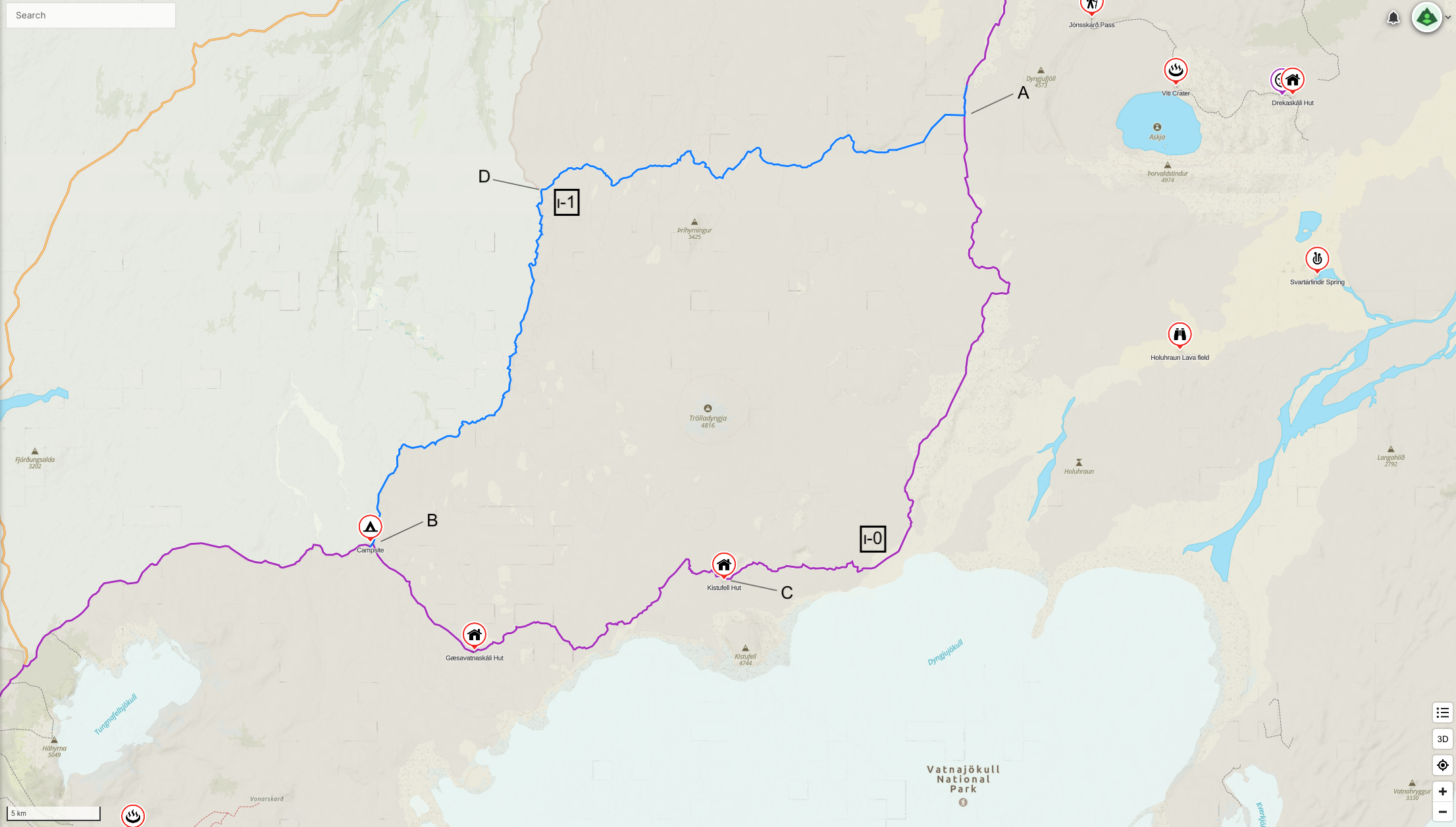
ι – Drier Route
There is an alternative to the North and West of the base route that appears to be drier with less severe river crossings. It is also 11 kms shorter and avoids the F26 4×4 gravel road. This drier alternative can not be combined with θ – Adding Lake Askja. Will need to check drinking water sources are available prior to taking this route. The base route has us walking closer to the glacier and appears to be the route most often taken by others. It also has Kistufell emergency shelter and Gæsavatnaskáli Hut along the way.
| Route | Routing | Distance (kms) | ↑/↓ (m) |
|---|---|---|---|
| ι-0 | A → C → B | 68.5 | 1,324 / 1,420 |
| ι-1 | A → D → B | 57.3 | 361 / 420 |
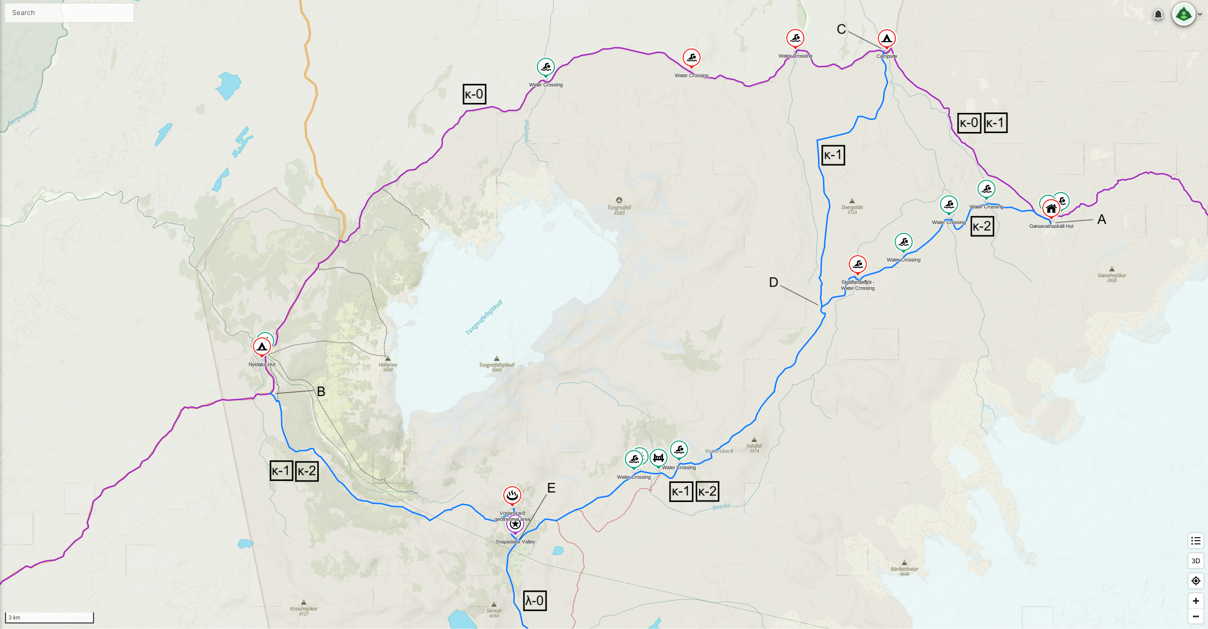
κ – South of Tungnafellsjökull
The base route passes to the North of Tungnafellsjökull, while this alternative passes to the South. In both cases the routes go to Nýidalur Hut, which is good, as we may have a food drop waiting for us there. If we do not have a food drop waiting for us, then it is possible to go from κ-1 or κ-2 to λ-0. The southern λ-0 alternative is 10 kms longer, but includes the Vonarskarð geothermal area and the picturesque Snapadalur Valley. There is a shorter route (κ-2) but it crosses the Skjálfandafljót river, which might be impassable or there may even be quicksand, as indicated with a red swimmer in the image below. There is also the Gjósta – Svarthöfði trail, the first half can be done when heading to Nýidalur Hut and the second half when leaving Nýidalur Hut, if the λ – Southern Route to Fjallabak National Park alternative is taken.
| Route | Routing | Distance (kms) | ↑/↓ (m) |
|---|---|---|---|
| κ-0 | A → C → B | 37.2 | 982 / 1,114 |
| κ-1 | A → C → D → B | 47.1 | 1,196 / 1,322 |
| κ-2 | A → D → B | 38.1 | 992 / 1,129 |
λ – Southern Route to Fjallabak National Park
The southern route to Fjallabak National Park avoids the F26 road. It is 25 kms longer. It is possible this alternative is impassable due to flooded rivers or snow lingering on the ground. The main advantage of this alternative is that it is more remote. There do not seem to be more things to see and do along the way. The orange trail is based on a publicaly published GPS track. The base route is probably more trustworthy, but we will need to share the road with the occasional 4×4 vehicle. Although not described in the table below, it is also possible to start on the λ-1 and at E head back to the base route on λ-2. Both λ-1 and λ-2 involve walking across open terrain where there is no marked or established trails.
If we do not have a food drop at Nýidalur Hut, then it is about 230 kms from Dreki Hut to the food drop at Landmannalaugar. This is a long but doable food carry.
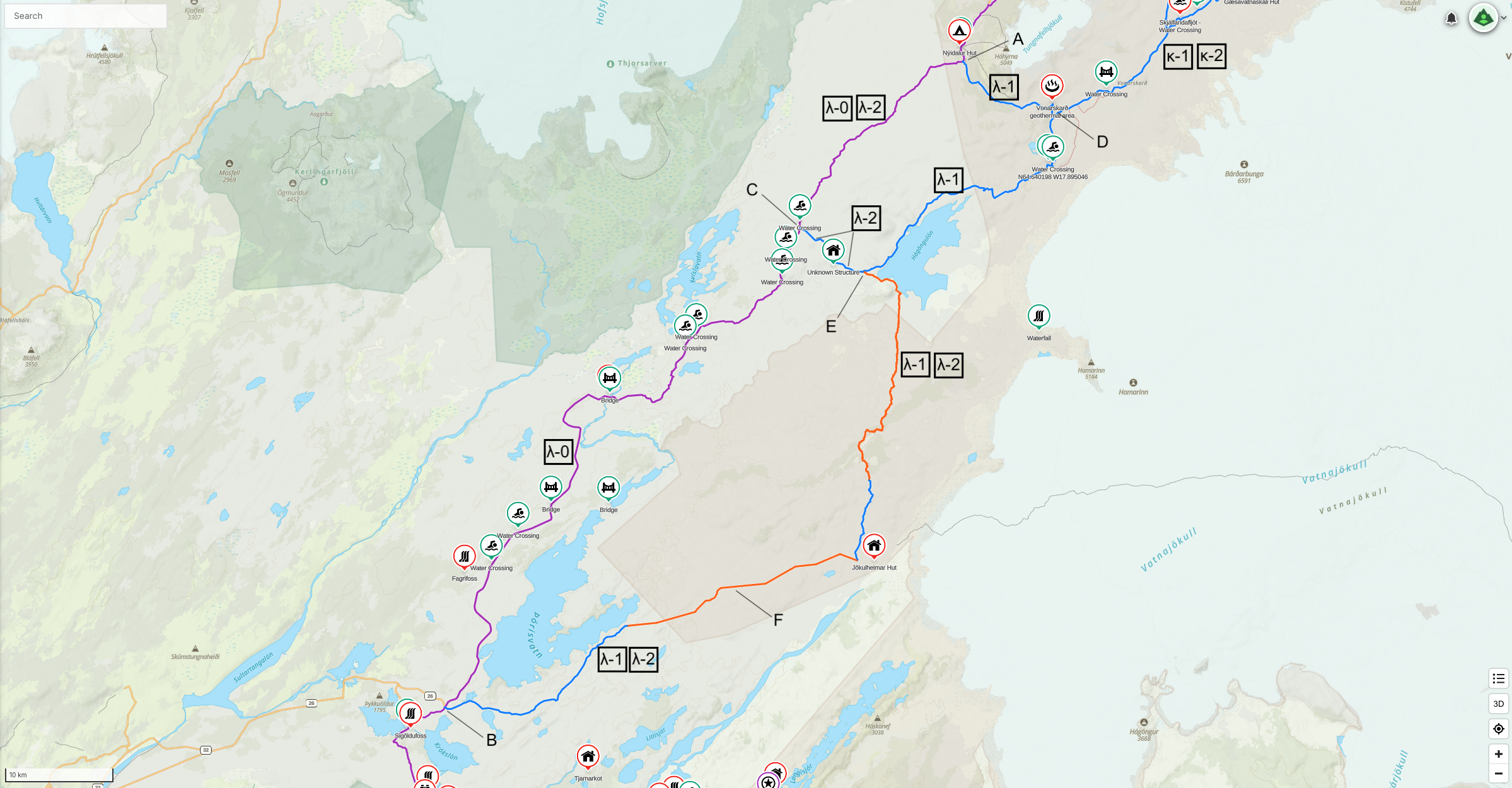
| Route | Routing | Distance (kms) | ↑/↓ (m) |
|---|---|---|---|
| λ-0 | A → C → B | 95.8(*) | 2,467 / 2,747 |
| λ-1 | A → D → E → B | 121.2 | 2,412 / 2,767 |
| λ-2 | A → C → E → B | 115.0 | 2,154 / 2,447 |
(*) This distance is a little deceptive if an alternative to κ – South of Tungnafellsjökull is taken. A to D is 12.5 kms, and this could be avoided in both directions saving 25 kms. This makes λ-0 and λ-1 effectively the same distance.
μ – Along Black Sand Beach
Good alternative to avoid 22 kms of a busy road and instead enjoy the black sand beach. There is a crashed DC-3 to visit along the way. Low tide is at 11:34am (on August 7th, 2025).
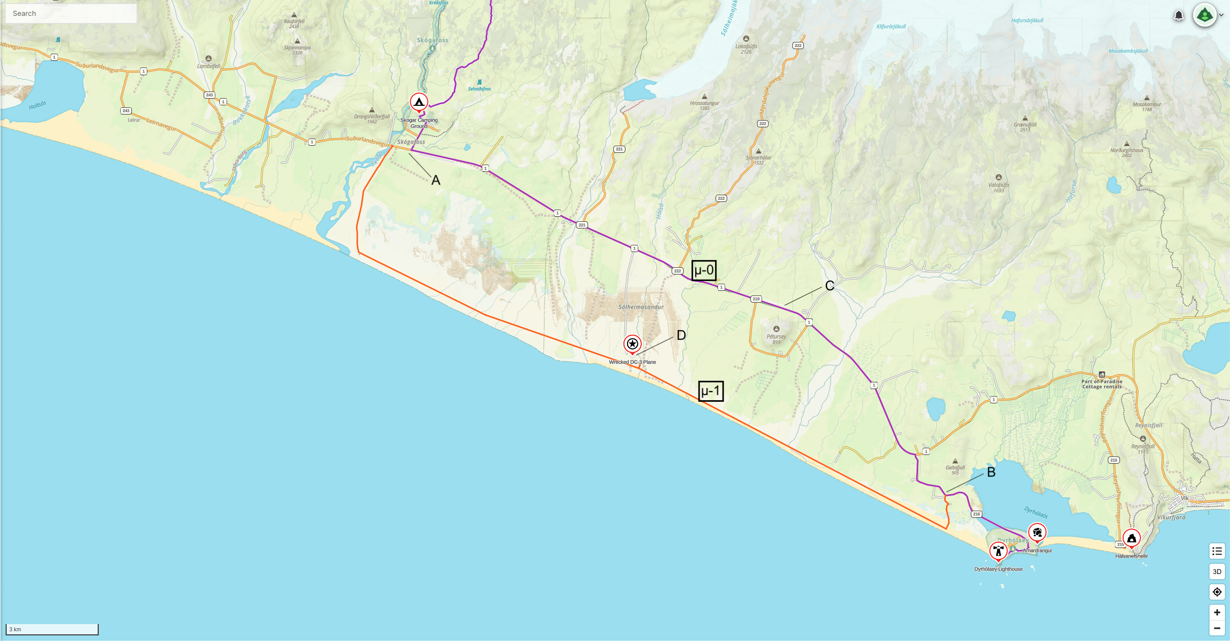
| Route | Routing | Distance (kms) | ↑/↓ (m) |
|---|---|---|---|
| μ-0 | A → C → B | 21.7 | 98 / 113 |
| μ-1 | A → D → B | 26.9 | 87 / 104 |
ν – Avoid F26
Just discovered a new route to by-pass a good chunk of the F26. It is a little longer, but not on the F26..
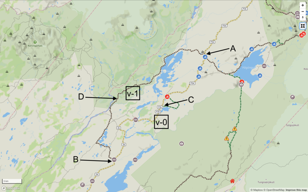
| Route | Routing | Distance (kms) | ↑/↓ (m) |
|---|---|---|---|
| ν-0 | A → C → B | 46.5 | 1,238 / 1,410 |
| ν-1 | A → D → B | 52.5 | 1,102 / 1,279 |
ξ – Remain on Gravel Road
This alternative goes North of Lake Eilifsvötn and has the advantage that the route remains on a gravel track. The base route goes South of Lake Eilifsvötn and has a section which is off-trail. The alternative is of course longer. There is also an option to go to Hliðarhagi Hut, which adds about 2 kms. Or to the Lake yet another 2 kms.
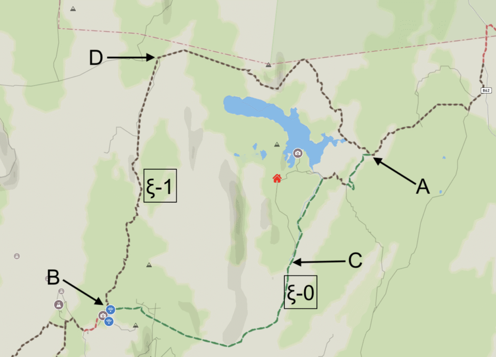
| Route | Routing | Distance (kms) | ↑/↓ (m) |
|---|---|---|---|
| ξ-0 | A → C → B | 15.0 | 334 / 115 |
| ξ-1 | A → D → B | 22.2 | 528 / 292 |